Snowfall Information
Below are maps, descriptions, and forecast discussions for 2017-2018 winter storms.
April 2
A quick moving band of snow associated with a low pressure system will move east across the area Monday morning, bringing 2-4 inches of snow from 5-10am. Roads may be slushy at times but temperatures and April's sun angle will prevent most of the snow from accumulating.
A quick moving band of snow associated with a low pressure system will move east across the area Monday morning, bringing 2-4 inches of snow from 5-10am. Roads may be slushy at times but temperatures and April's sun angle will prevent most of the snow from accumulating.
March 20-21
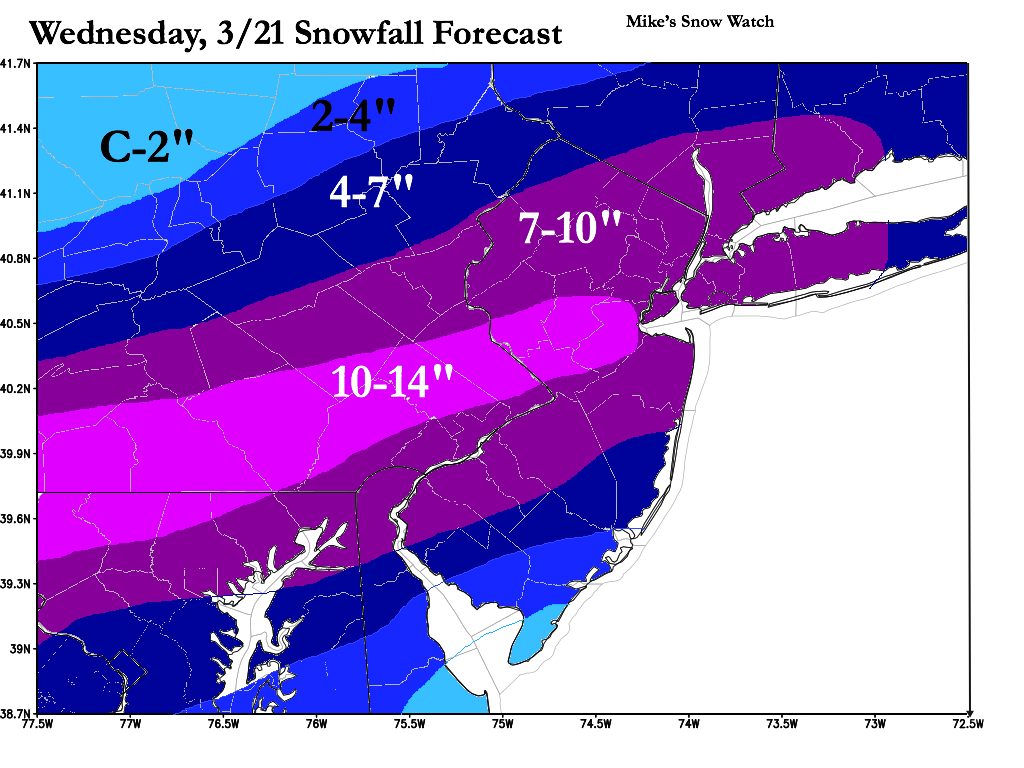
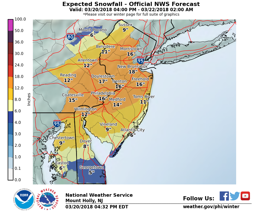
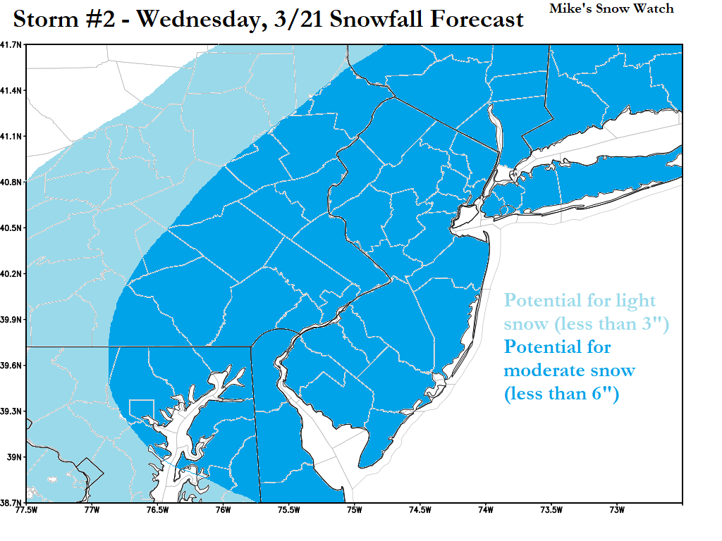
Wednesday Midday: The forecast is mostly going as planned, except for a small hole in the snow banding that occurred mid-morning. Snowfall in our area will still amount to about 6-10" by the end of the storm. The high sun angle of late March as well as the 32 degree temperature are at work, melting much of the snow on roads and parking lots. At this stage in the storm, it appears that the National Weather Service's forecast is unfounded, and the Mike's Snow Watch forecast (for just over half of what the NWS has forecasted) will validate.
Wednesday Midday: The forecast is mostly going as planned, except for a small hole in the snow banding that occurred mid-morning. Snowfall in our area will still amount to about 6-10" by the end of the storm. The high sun angle of late March as well as the 32 degree temperature are at work, melting much of the snow on roads and parking lots. At this stage in the storm, it appears that the National Weather Service's forecast is unfounded, and the Mike's Snow Watch forecast (for just over half of what the NWS has forecasted) will validate.
Tuesday PM Entry: Snow will begin around 6am Wednesday and continue through 2am Thursday. 6-10 inches of snow expected generally, much less on roads. See map below for location-specific totals. (*Note: our map and the NWS map were created within an hour of one another. The NWS will continue to update their map every 12 hours to ensure the safety of its viewers. This, however, will be a test judging whose forecast validates best, since there is such a large discrepancy between the two.*)
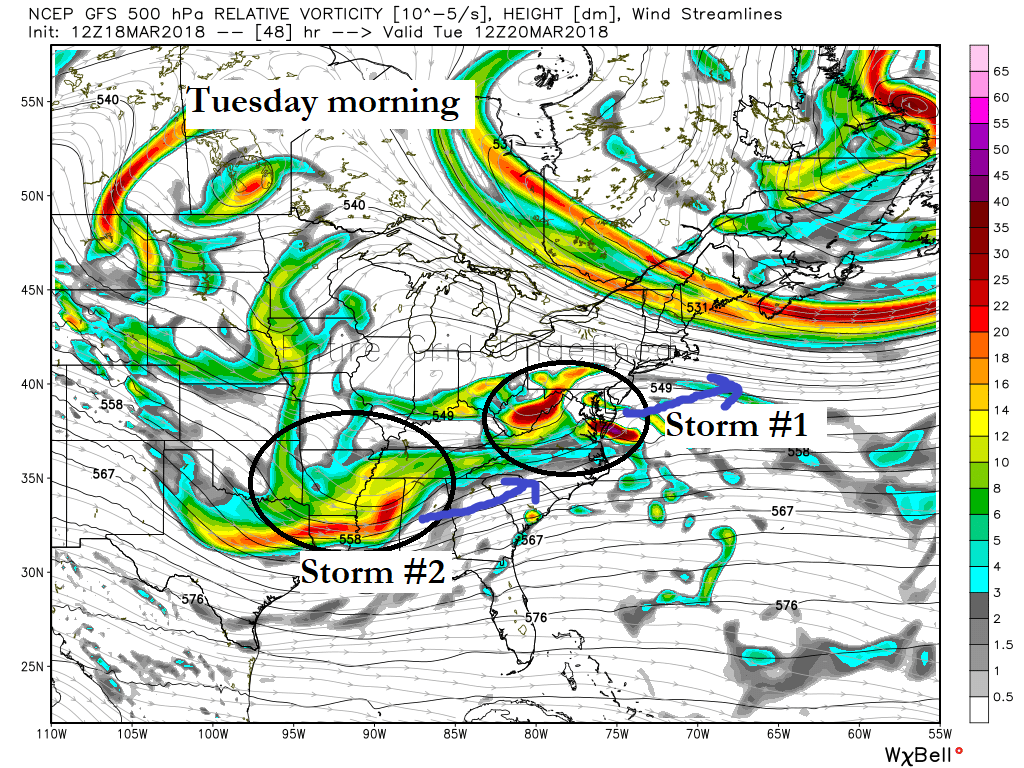
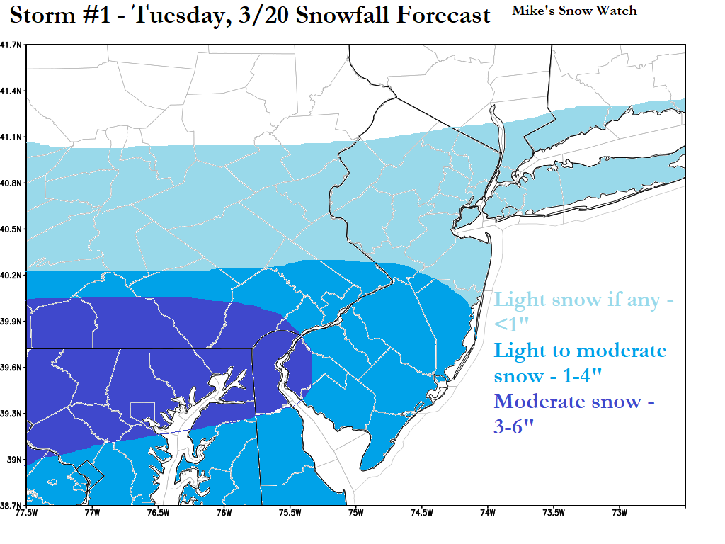
Sunday 2PM Entry: Two pieces of energy in the atmosphere will be moving across the mid-Atlantic during this time frame. Initially, models suggested that these two pieces would phase, or come together, and form a strong nor'easter that would track up the coast, impacting our area. Recently, however, models and forecasters have backed away from that idea since observations have pointed toward a more separate movement. We can confidently conclude now that these two pieces of energy (depicted below) will NOT combine. The outcome is two weaker storms. The first will pass by to our south on Tuesday, likely bringing no more than some light snow to the area (see Storm #1 below). The second storm will form and track to our southeast on Wednesday. This one, depending on its track, could pass by without an impact or bring precipitation to the area in the form of a moderate snow event (~3-6 inches).
March 12
Another coastal storm will be taking shape in the mid-atlantic, but the piece of energy in the atmosphere that captures the storm and causes it to strengthen remains farther northwest. As a result, the storm takes a farther east track and doesn't produce heavy snow until it reaches New England. 1-3 inches expected late Monday night.
Another coastal storm will be taking shape in the mid-atlantic, but the piece of energy in the atmosphere that captures the storm and causes it to strengthen remains farther northwest. As a result, the storm takes a farther east track and doesn't produce heavy snow until it reaches New England. 1-3 inches expected late Monday night.
March 7
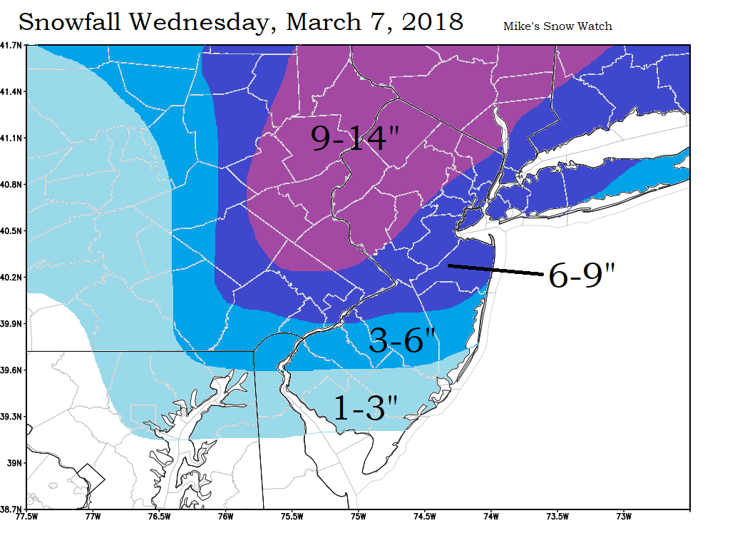
A coastal storm will develop inside 40N & 70W (an ideal setup for northeast snow) and continue northeast as it develops. See map below for accumulations
A coastal storm will develop inside 40N & 70W (an ideal setup for northeast snow) and continue northeast as it develops. See map below for accumulations
February 2
A strong cold front will pass through with moisture on both sides of it. Rain will change to snow early Friday morning. A coating to an inch of snow is expected.
A strong cold front will pass through with moisture on both sides of it. Rain will change to snow early Friday morning. A coating to an inch of snow is expected.
January 29-30
A system that develops a coastal storm that goes out to sea will leave a piece of moisture behind on an arctic front, yielding a chance for snow Monday afternoon into Tuesday.
A system that develops a coastal storm that goes out to sea will leave a piece of moisture behind on an arctic front, yielding a chance for snow Monday afternoon into Tuesday.
January 16-17
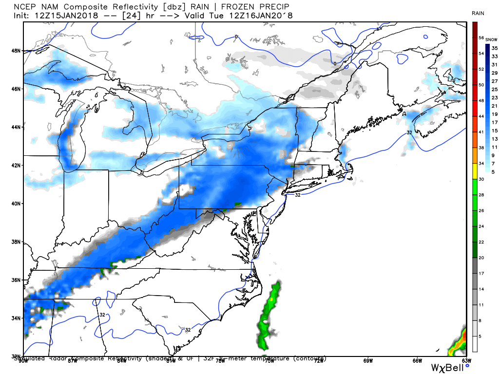
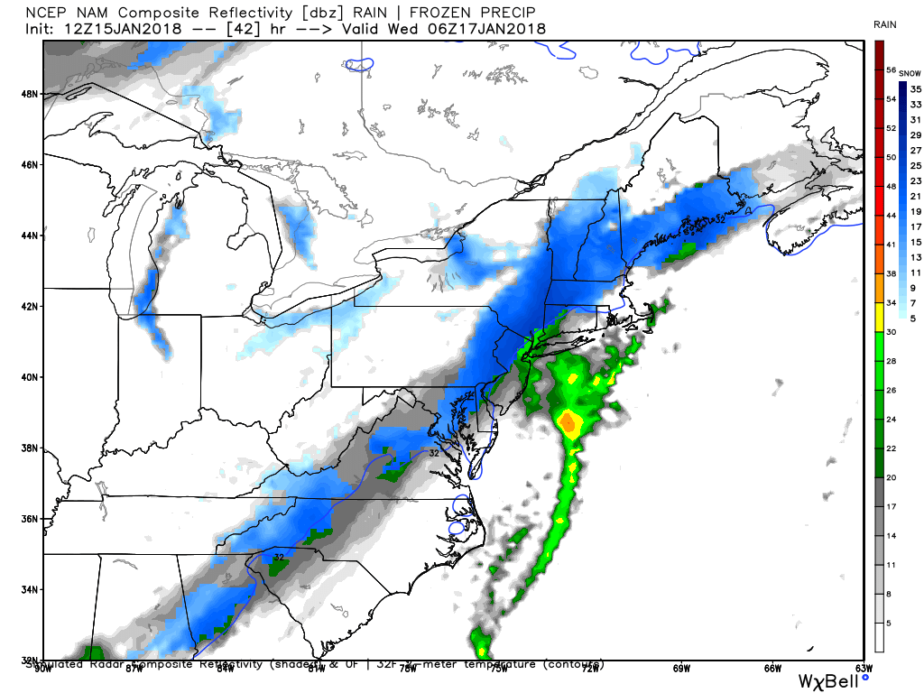
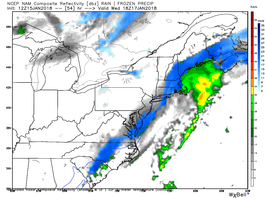
A clipper diving southeast is expected to die out but leave a boundary from Ohio to Texas behind which a long strip of snow will develop. As the boundary slowly pushes east on Monday night and Tuesday, a coastal disturbance off of North Carolina will slowly move north and begin to interact with the front. By Wednesday morning the coastal disturbance becomes a strengthening low pressure system that delivers moderate precipitation as in moves northeast. The scenario is depicted below (images courtesy WeatherBELL Analytics) Updated-1/15 2:36 PM
First image - Tuesday morning
Second image - Late Tuesday night
Third image - Wednesday afternoon
January 13-14
A storm around January 9 with cut up into the Great Lakes, providing some much needed temperature relief (in the form of 45 degrees and rain). As the storm exits an arctic high pressure system will press the remaining front/boundary line southeastward. A wave of low pressure will form along this boundary and ride along it as it slowly presses southeast. If this boundary pushes very slowly, a batch of rain will cover the area from the 13th to 14th. If the boundary pushes more quickly, arctic air will be closer and the storm will form farther east, allowing this precipitation to be in the form of ice or snow,
A storm around January 9 with cut up into the Great Lakes, providing some much needed temperature relief (in the form of 45 degrees and rain). As the storm exits an arctic high pressure system will press the remaining front/boundary line southeastward. A wave of low pressure will form along this boundary and ride along it as it slowly presses southeast. If this boundary pushes very slowly, a batch of rain will cover the area from the 13th to 14th. If the boundary pushes more quickly, arctic air will be closer and the storm will form farther east, allowing this precipitation to be in the form of ice or snow,
January 8
A small batch of precipitation from an overrunning/warm advection system will spread across the area around 2pm and last until 5pm. It will begin as freezing rain (liquid rain that freezes once it hits the ground) and then turn to sleet (ice pellets that loudly strike the ground) eventually ending as snow. Total accumulation across the area will be a thin glaze of ice and a dusting of snow.
A small batch of precipitation from an overrunning/warm advection system will spread across the area around 2pm and last until 5pm. It will begin as freezing rain (liquid rain that freezes once it hits the ground) and then turn to sleet (ice pellets that loudly strike the ground) eventually ending as snow. Total accumulation across the area will be a thin glaze of ice and a dusting of snow.
January 4
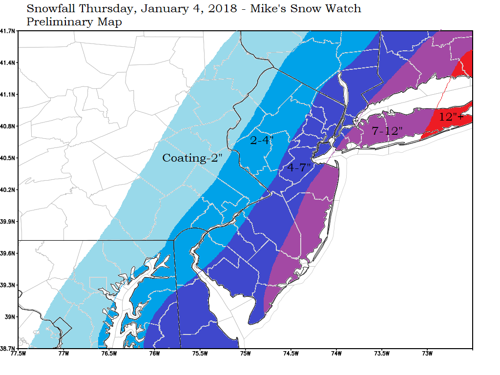
A large coastal storm will begin to form east of Florida and track north-northeast, strengthening over the relatively warm Atlantic ocean.
A large coastal storm will begin to form east of Florida and track north-northeast, strengthening over the relatively warm Atlantic ocean.
December 30
An Alberta Clipper will drop down from the northern Plains and quickly moving off the mid-Atlantic coast, dropping a coating to a couple of inches along its path.
December 25
A piece of energy coming from the Plains will combine with a piece of coastal energy and create a large snowstorm for New England. Here, the phase of energy will occur too late for significant snows. a coating to an inch or two is expected with marginal temperatures (around 32).
December 17
A quick shot of snow is expected Sunday night before turning to light ice and then light rain. Impacts should be minimal as any precipitation will be light and temperatures rise above freezing during or shortly after precipitation.
December 15
A period of snow will develop from about 3PM Friday to 7PM Friday as a weak coastal storm begins to strengthen as it exits. Thus, coastal areas will receive the largest amount of snow. See snowfall map below.
December 13-14
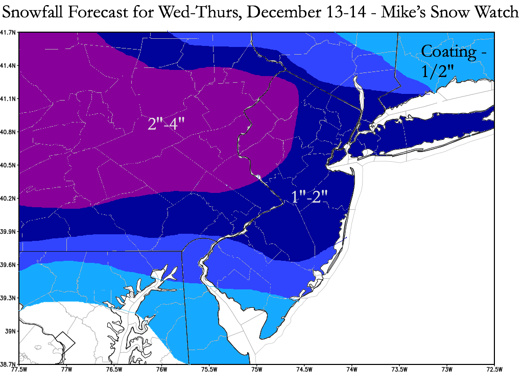
A clipper moving southeastward from the Great Lakes region will impact the area beginning 11PM Wednesday night and continuing until day break on Thursday. Temperatures at the surface and in the atmosphere will be very cold, so a coating to an inch or two of fluffy snow is forecasted. Expect the snow to stick on all surfaces. See snowfall map below.
A clipper moving southeastward from the Great Lakes region will impact the area beginning 11PM Wednesday night and continuing until day break on Thursday. Temperatures at the surface and in the atmosphere will be very cold, so a coating to an inch or two of fluffy snow is forecasted. Expect the snow to stick on all surfaces. See snowfall map below.
December 9
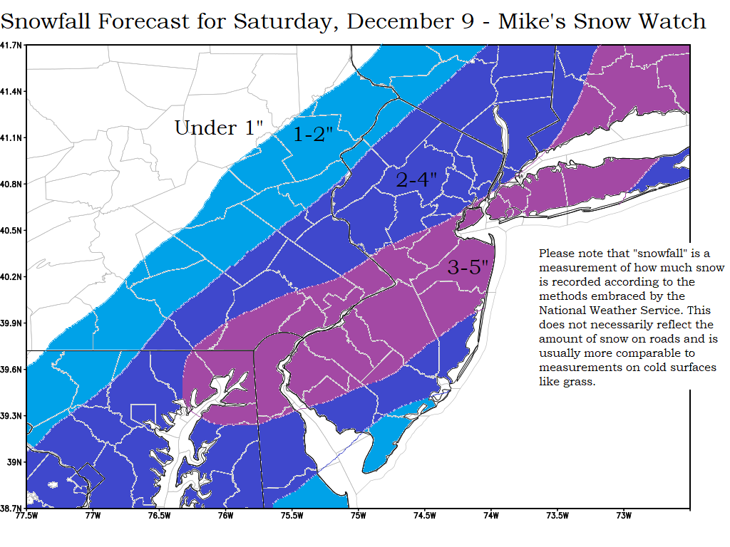
A storm near the Gulf of Mexico on Friday, December 8 will be moving up the coast and off the Carolinas Saturday as it strengthens. It will bring snow to the northeastern coastal areas. See snowfall map below.
A storm near the Gulf of Mexico on Friday, December 8 will be moving up the coast and off the Carolinas Saturday as it strengthens. It will bring snow to the northeastern coastal areas. See snowfall map below.

