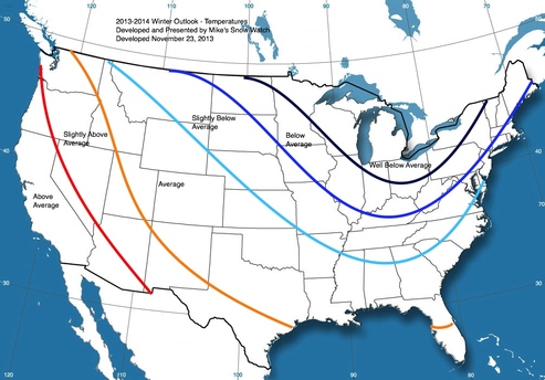
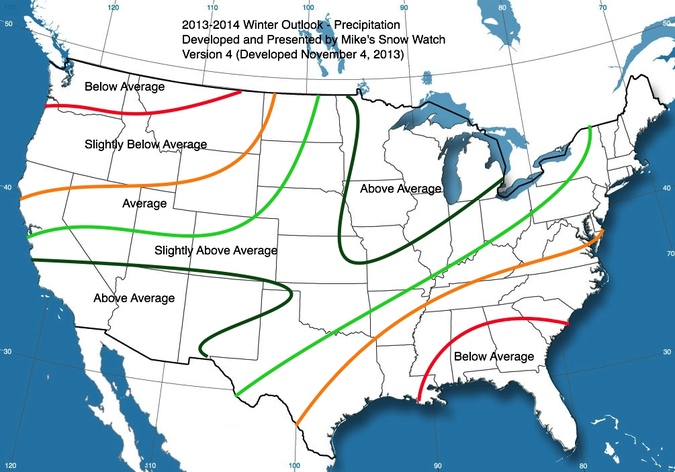
The FinalWinter Forecast has been released!
Temperature Forecast
Slideshow
Precipitation Forecast
Winter Forecast
Factors:
1. El Niño/Southern Oscillation- It has been relatively neutral lately, and it is predicted to veer to a very slightly positive (very weak El Niño) throughout the winter. This would result in a slightly active southern jet, potentially resulting in the return of nor'easters.
2. Pacific Decadal Oscillation - The PDO is predicted to continue its negative trend, as the world is currently entering a global cooling period for the next 20-25 years (Hence the great increase of sea ice on both poles this year).
3. Sunspots - The sunspot cycle has peaked already, and is heading down just in time for the next few winters. This could also mean a cooler winter (See home page).
4. North Atlantic Oscillation, Arctic Oscillation- They are too far out to predict for the winter, but currently, they are trending toward a neutral pattern. If this pattern continues through the fall and winter it would mean average temps & precip.
5. Models - Thus far, the ECMWF and CFSv2 both show a cool winter with average precipitation for the northeast which is a good sign, but not a giveaway. It is good to see models in agreement with the pattern.
6. Southern Oscillation Index- The SOI has been generally neutral lately. A consistently positive SOI means La Niña conditions while a consistently negative SOI means El Niño conditions.
7. Pacific-North American - The PNA is predicted to stay positive throughout most of the winter. Models JAMSTEC, ECMWF & CFSv2 agree.
Summary:
Thus far, patterns and analogs have lead forecasters to believe an exceptionally chilly winter is to come. Additionally, patterns show wet conditions throughout the winter. However, some models have been pointing otherwise, instead showing cold and dry conditions throughout the first part of winter. Combining historical knowledge, analogs, patterns, observations, and models, Mike's Snow Watch has come to the conclusion that winter will be chilly with normal precipitation. Therefore, snowfall will be slightly above average. It will be a slow start to winter, and although cold, probably only one snow event late in the month will affect the area. January will bring warm temperatures in the first half, and then cooler temperatures in the latter half of the month. January will be a transition month, with wild temperature swings. February will bring cold temperatures with heavier precipitation, with the threat of numerous snow event affecting the area. Lastly, March will be an average month, with possibly a small storm, but with the angle of the sun so high in March, the snow often doesn't stick to many surfaces. Check back often to be aware of the latest information!


